The outlook for this year’s Atlantic hurricane season—which officially kicks off on June 1 and runs to November 30—remains somewhat uncertain. After a rare ‘triple-dip’ event—a three-year La Niña cycle—the NOAA National Weather Service has pointed to a greater than 90% chance of an El Niño event beginning in the next few months and continuing through winter.
El Niño is a climate pattern in the Pacific Ocean characterized by above-average sea surface temperatures. During El Niño, trade winds weaken, and warm water is pushed back east toward the west coast of the Americas. This would favor greater cyclone development in the Western Pacific as opposed to the Atlantic Basin. For this reason alone, and with ocean surface temperatures on the rise, experts have admitted that there is a degree of uncertainty when predicting the likely meteorological events of the coming months, with some forecasts suggesting that 2023 Atlantic hurricane season activity may, somewhat refreshingly, be 'below average' this year.
However, residents up and down US coastlines know better than to be complacent. This decade, so far, has been hard, a tricky one to second guess, perhaps best exemplified by the late formation of Hurricane Ian last year on September 22, which developed into a Category 5 event and caused $113 billion dollars in damage and significant loss of life.
NOAA’s 2023 Atlantic Hurricane Season Outlook, most recently updated on May 25, now forecasts a “near-normal” hurricane season, which equates to 12–17 named storms (including 5–9 hurricanes, 1–4 of which may develop into major hurricanes) predicted between June 1 and November 30. Either way, knowing that it only takes one storm to devastate communities, local, state, and federal governments remain prepared for the worst.
THE NEED FOR CLARITY & PLANNING
As was the case with Ian, authorities and the populations they represent are often faced with difficult and time-sensitive decisions when greenlighting hurricane preparations and ordering evacuations and hurricane forecasts—these moments call for clarity, not uncertainty. Over the years, major storm events have shown time and time again how delays in mandated evacuations caused by forecast uncertainty can result in catastrophic loss. One needs only remember the widespread devastation left by Hurricane Katrina in 2005 to understand the critical importance of timely, data-led decision-making.
Thanks to collaborative efforts to introduce new research and technological advancements into the field, initiatives like the 2008 Hurricane Forecasting Improvement Project Plan launched by NOAA, the accuracy of hurricane forecasts have never been more accurate; with every passing year, authorities are able to feed vast swathes of validated data into sophisticated predictive models which today provide a vital tool for emergency management and coastal protection.
COLLABORATIVE APPROACH TO TECH-LED DATA COLLECTION
This is a year-round undertaking, as opposed to event specific. NOAA’s Atlantic Oceanographic and Meteorological Laboratory (AOML) underwater glider program, run out of Miami, FL, is just one example of how advanced ocean technology is aiding the oceanographic community to collect pre-, during-, and post-storm data safely and efficiently. Gliders can be deployed and recovered a few miles from the coast from small support boats, are remotely piloted from the ground, and can remain at sea for up to nine months. This allows scientists to gather target data, especially those relating to the variables known to fuel rapid intensification and path predictions, which are then incorporated into ocean models for improved hurricane intensity forecasts.
NOAA/AOML currently has a fleet of approximately 10 gliders to monitor the Atlantic Basin to feed researchers with the data they need to update forecasts and findings in the run-up to, months of, and aftermath of the Atlantic Hurricane season.
IN THE EYE OF THE STORM
More recently, to improve hurricane forecasting and grow the understanding of real-time air-sea interactions, investments have been made to outfit uncrewed surface vehicles (USVs) with the equipment and sensor suites needed to capture in situ data and ultimately fill in the knowledge gaps.
Salidrone, a leading developer of USVs of various size, range, and endurance, in partnership with NOAA, has been testing uncrewed technology to the limits in recent years by sending custom USVs into the eye of several major hurricanes, including Sam (Category 4) in 2021, capturing unprecedented video footage of towering waves and violent winds. When technologists talk about sending robots to carry out tasks in environments deemed too hazardous for humans, this is what they refer to.
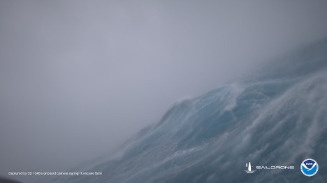
Images captured from inside Hurricane Sam by a Saildrone USV in 2021. (Image credit: Saildrone)
Beyond the captivating audiovisual record of nature at its most hostile, USV hurricane missions, thanks to the sophisticated payload they deploy, provide researchers and scientists with critical hurricane data that will continue to improve future storm intensity and track predictions.
ADDRESSING THE AFTERMATH
USVs can also be instrumental in helping assess coastal conditions before and after major weather events. Increasingly, coastal hydrographers are deploying USVs (as well as autonomous underwater vehicles—AUVs) equipped with multibeam sonars and other remote sensing systems to better understand the cumulative post-event impacts of extreme weather patterns on shorelines and their native ecosystems. Geospatial records that demonstrate shifts in variables over time are fundamental to ongoing coastal planning and restoration projects.
Furthermore, there are other more immediate post-storm surveys that smaller USVs are uniquely equipped to handle, such as emergency response. In the case of catastrophic damage to coastal communities, such as with Hurricane Ian in 2022 or Hurricane Dorian in 2019 (a Category 5 that wreaked widespread havoc in the Bahamas before going on to cause significant coastal erosion up the US east coast), portable USVs can be deployed in waters that may be restricted by debris or contaminated in some other way—that is, in zones of crisis where it is always preferable to send a robotic asset over a traditional survey vessel with crew.
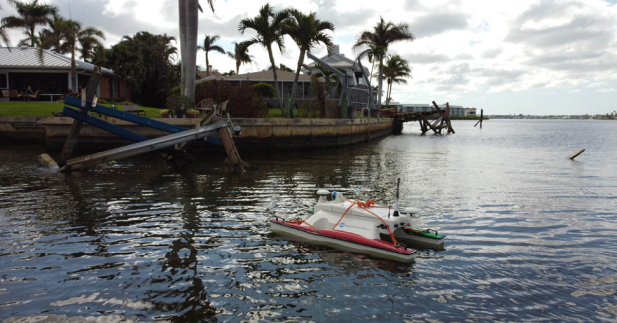
PORTABLE USVs
SeaRobotics’ SR-Surveyor M1.8 is ideally suited to such work and has been successfully deployed on multiple survey missions following major hurricane landfalls, including those of Hurricanes Ian and Dorian.
Supported by an EdgeTech 2205 and Velodyne LiDAR, and at only 1.8 meters in length, the fully integrated USV delivers synchronized data capture of two frequencies of side scan, motion tolerant side scan, wide swath bathymetry, backscatter, LiDAR point cloud data, and discharge data. In short, this means that coastal resource managers can quickly and safely execute search and rescue missions, identify dangerous underwater debris, inspect potentially damaged subsea infrastructure, and navigate potentially hazardous waters, all without the reliance on traditional topside support.
The growing acceptance of uncrewed vehicle technology, especially USVs, is a win-win for coastal marine surveys and all-year-round hurricane response planning. Notwithstanding the benefits in terms of safety and efficiency, the advances in sensor technology also help eliminate the margin of human error (and stresses) associated with manual deployment.
Timing is critical when it comes to measuring the cumulative impacts of extreme weather on a coastline—an environment that by its very nature is in constant flux—and USVs offer the fastest, safest, and most reliable route to data-led decision-making.
To find out more about SeaRobotics’ current portfolio of USVs, visit: www.searobotics.com.